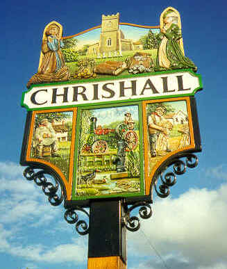
Designed by Sue Davies, the village sign depicts The Holy Trinity Church and the graves of the Brand family who left a trust fund to the village and the Church. Beneath this on the left is The Red Cow while on the right is The Methodist Chapel. In the centre is a traction engine, reflecting Chrishall’s Victorian agricultural heritage, and one of the village’s 5 ponds and 5 pumps.
It is best to think of the centre of the village as the cross roads at the small triangular green where the war memorial and the village sign are located and to picture each road leading from this centre.
Immediately opposite and to the south of the war memorial is Loveday Close, a small development of attractive, modern houses.
North -east from here runs Crawley End – a long road (which passes through what may seem almost a separate settlement) and which eventually leads past the turn to Elmdon. Half way along this road is Wire Farm, itself surrounded by open fields. Chrishall Methodist Chapel is located here, being the first building on the left (north side) after the open fields. At the far end are (former) council houses and on your right hand side as you leave the village are two culs de sac: Engleric and Pinkeneys.
North -west from the centre runs Palmer’s Lane, leading to Abrams Lane. The village school, community centre and playing fields are accessed from Palmer’s Lane near the centre. A few hundred yards on the left where palmer’s Lane becomes Abrams Lane is Broad Green – a cul de sac lane.
South-west from the centre runs the High Street. Our ancient pub The Red Cow is here at the junction with the very narrow Hogs Lane (sometimes called Red Cow Lane), as was our volunteer run Village Shop. Down the High Street on the left hand side is Brick Row, a long terrace of houses dating from the middle of the 18th century. The High Street continues down to the main Saffron Walden – Royston road (B1039) but before that a small lane called Chalky Lane links across to Church Road. Church Road runs south-east from the centre and unsurprisingly, the Holy Trinity Church is accessed from it just before it too, reaches the B1039.
Finally, a few houses are located on Mill Causeway. This road leads up from the far end of Abrams Lane to the far end of Crawley End, just before the Elmdon turn.

0 Comments